RIDE ATLAS

RideAtlas_720
RideAtlas

Purpose

The RIDE ATLAS (Aerial Terrain Line of Sight Analysis System) integration represents a vision of a complete, better package of ATLAS rebuilt within RIDE.

How to Use

Access ATLAS functionality via the new RIDE button found in the bottom left corner of the UI.

The Home button returns the camera to the default position.

The Unit Builder menus allow users to customize infantry and ordnance BLUFOR and OPFOR units.

Edit any placed unit on the terrain by double-clicking/tapping on the unit or clicking/tapping the Edit (Pencil) icon for the placed unit in the Unit Pool menu.

Modify the unit name in its properties pane once selected from the pool menu.

Agent LOS

  • Individual Blue/Red agents display a LOS radius corresponding to their respective color. This radius will appear obstructed by terrain and structural obstacles. 
  • Where instances of agent LOS radii overlap their colors will intensify.

Overlays

  • MGRS Grid – toggles grid lines
  • Contour Lines – toggles terrain contour lines

Shading

  • Terrain – default visualization
  • Slope – toggle between Green-Red and Panchromatic
  • Elevation – toggle between Green-Red and Desert Mono

Camera

  • Right-click and hold to adjust camera orientation
  • Press WASD keys to move camera
  • Press QE keys to rotate camera
  • Hold Space bar to raise camera
  • Hold Ctrl to lower camera

Scene Location & Name

Assets/Scenes/RideAtlas/RideAtlas.unity

Note

Currently the source files for this scene are not included in our external distribution. This scene is only available in binary format via standalone build. Please contact us to request a build.

Setup Requirements

This scene incorporates many features and systems within RIDE.

RideSystems Prefab Script

Add this prefab to the scene. Under ResourceLoader nested prefab, under Unit Prefabs, add prefabs WaypointVisualizer, LocationMarker and Ordnance.

Terrain-related Prefabs

Instance the following prefabs to enable loading of a navigable terrain map and related features:

  • TerrainCameraLOS prefab – contains mask component for LOS system; replaces MainCamera
  • TerrainCenter object – sets default camera position relative to placement on map at run-time
  • TerrainDestructor prefab – enables simple explosions via mouse click at run-time
  • TerrainLoader prefab – defines the terrain map for loading
  • TerrainNavLoader prefab – unit navigation of terrain
  • TerrainMeasureDistance prefab – Point measurement UI 
  • GeoreferenceLocationMarkerMenu prefab – Enable placement of georeference location markers

RideAtlas Script

The main scene logic script. Link various scripts in the fields as referenced.

Compass Menu Prefab

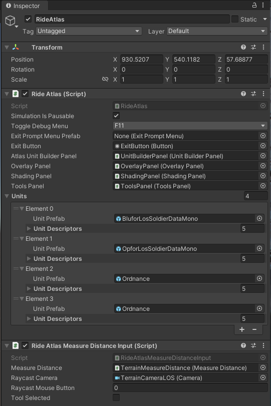
Enables onscreen compass UI. Note, prefab dependent upon CompassMenu script found in RideAtlas sub-folder. 

Unit Placement Script

Required to instance units on terrain via UI menu.

Canvas and Related Prefabs

Consists of the the various buttons, panels and menus for the UI. 

Known Issues

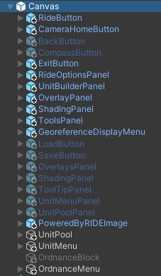
Multiple known issues exist in this prototype scene currently, with the intention of addressing them with future releases.

  • Unit pathing option not available
  • Cannot remove measurement or georeference markers
  • Units engage prior to placement
  • Error occurs upon death of unit prior to placement
  • Performance degrades with multiple units present; mitigate by limiting onscreen units and reducing LOS value per unit
  • Waypoint lines over terrain may appear jagged